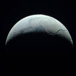
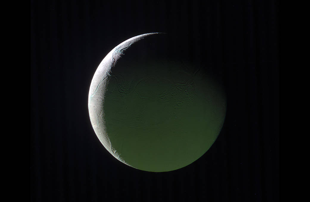
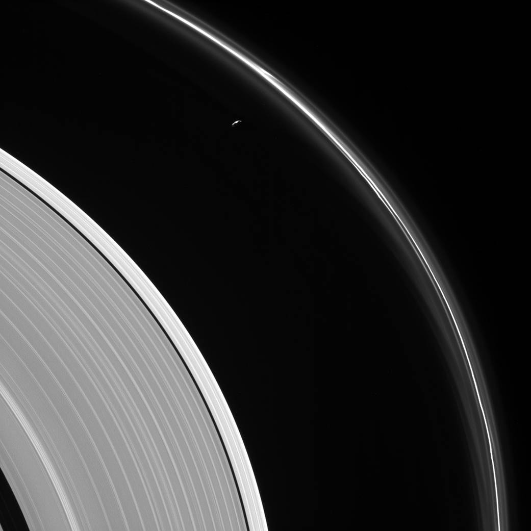
Saturn-lit Tethys
Cassini gazes across the icy rings of Saturn toward the icy moon Tethys, whose night side is illuminated by Saturnshine, or sunlight reflected by the planet.
カッシーニは土星の氷の環を通過する際に、夕日に照らされた土星の輻射光に照らされた氷の衛星テティスを撮影しました。
Tethys was on the far side of Saturn with respect to Cassini here; an observer looking upward from the moon’s surface toward Cassini would see Saturn’s illuminated disk filling the sky.
これまでテティスはカッシーニとは土星の遠い側にありました。衛星の表面からはカッシーニは上方に位置するので、土星が照らし出している土星の環が画像全体を満たしているように見えます。
Tethys was brightened by a factor of two in this image to increase its visibility. A sliver of the moon’s sunlit northern hemisphere is seen at top. A bright wedge of Saturn’s sunlit side is seen at lower left.
この画像ではテティスの視認性を高めるために2倍の明るさにしました。上部に衛星の北半球が銀色に輝いてみてます。輻射光に照らされている土星が左下に見えます。
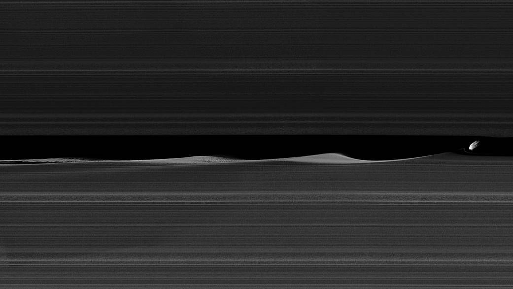
This view looks toward the sunlit side of the rings from about 10 degrees above the ring plane. The image was taken in visible light with the Cassini spacecraft wide-angle camera on May 13, 2017.
この画像は、土星の環の面の約10度上から、光のさす方向を向いています。2017年5月13日にカッシーニ探査機搭載の広角カメラで可視光で撮影されました。
The view was acquired at a distance of approximately 750,000 miles (1.2 million kilometers) from Saturn and at a Sun-Saturn-spacecraft, or phase, angle of 140 degrees. Image scale is 43 miles (70 kilometers) per pixel on Saturn. The distance to Tethys was about 930,000 miles (1.5 million kilometers). The image scale on Tethys is about 56 miles (90 kilometers) per pixel.
撮影位置は、土星からおよそ750,000マイル(120万キロメートル)の距離で、太陽 – 土星 – 探査機の位相が140度の角度で撮影されました。画像解像度は、1ピクセルあたり43マイル(70キロメートル)です。 テティスまでの距離は約930,000マイル(150万km)でした。 テティスの画像解像度はピクセルあたり約56マイル(90キロメートル)です。
The Cassini mission is a cooperative project of NASA, ESA (the European Space Agency) and the Italian Space Agency. The Jet Propulsion Laboratory, a division of the California Institute of Technology in Pasadena, manages the mission for NASA’s Science Mission Directorate, Washington. The Cassini orbiter and its two onboard cameras were designed, developed and assembled at JPL. The imaging operations center is based at the Space Science Institute in Boulder, Colorado.
Last Updated: Aug. 23, 2017
Editor: Tony Greicius
訳者注
記事にありますように、この画像では衛星テティスの視認性を高めるように明るさを2倍に画像処理を施されたものです。
下のサムネイル画像をクリックすると最大解像度(1041×1041)表示します。
Credit: NASA/JPL-Caltech/Space Science Institute